EXPLORATION: Layers and Plate Tectonics
| Site: | MoodleHUB.ca 🍁 |
| Course: | World Geography 30 |
| Book: | EXPLORATION: Layers and Plate Tectonics |
| Printed by: | Guest user |
| Date: | Wednesday, 24 December 2025, 11:19 AM |
Description
1. Layers of the Earth
How were Earth's layers discovered? What are they?
Earth's
interior is broadly grouped into three main layers on the basis of
chemical composition: crust, mantle, and core. An egg analogy is used to
show relative thicknesses, and a Big Hunk analogy illustrates how a
material of a single composition can be either brittle or ductile
depending on temperature. This animation shows briefly how scientists
figured out where these layers were, what the layers are, and how the
crust is often mistaken for the tectonic (aka lithospheric) plates.
Watch
the video below which explains the structure of Earth's layers as well
as the history of our understanding of this subject.
Keypoints:
- Layers were deduced by Sir Isaac Newton (1700) to Inge Lehmann (1937)
- Earth's three main layers: crust, mantle, core
- Layers are defined by composition
- Each layer has physical variations due to temperature and pressure
- The crust is only the upper part of the tectonic (lithospheric) plate.
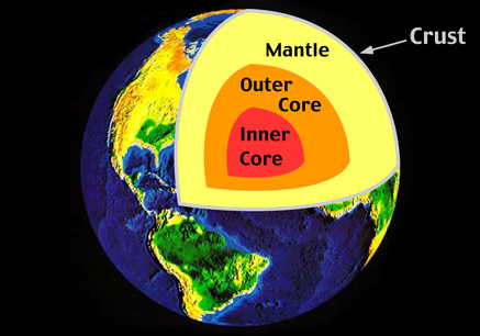
Courtesy: Dr. Michael Pidwirny, Department of Geography, UBC Okanagan
- Lithosphere (Crust)
- 5 to 64 km thick
- brittle shell of solid rock that cracks, warps, and bends
- thinnest on the ocean floors
- Mesosphere (Mantle)
- approx. 2900 km thick
- upper part is known as the asthenosphere
- very hot, approx. 1650 deg. C in upper part
- pliable, semiplastic
- driving force for volcanoes, mountain building, and continental drift
- located in the upper mantle
- partially molten (i.e. approx. 10%)
- lithosphere "floats" on top of the asthenosphere
- zones that have become molten, or partially molten, can develop convection currents
- convection currents in the asthenosphere are responsible for plate movement(Note: Convection currents in the outer core are partially responsible for the earth's magnetic field but do not drive the tectonic plates)
- Core or Centrosphere
- approx. 2900 km thick
- Outer core: likely made of liquid iron
- Inner core: believed to be solid iron, 4000 to 6000 deg. C, inner heat believed to be caused by the decay of radioactive rock
2. Plate Tectonics
Plate Tectonics
The earth's surface is broken into seven large and many small moving plates. These plates, each about 80 km thick, move relative to one another an average of a few centimetres a year.
Three types of movement are recognized at the boundaries between plates:
-
convergent
Convergent boundaries are areas where plates move toward each other and collide. Where an oceanic plate collides with a continental plate, the oceanic plate tips down and slides beneath the continental plate forming a deep ocean trench (long, narrow, deep basin.) An example of this type of movement, called subduction, occurs at the boundary between the oceanic Nazca Plate and the continental South American Plate. Where continental plates collide, they form major mountain systems such as the Himalayas.
-
divergent
At divergent boundaries, plates move away from each other such as at the Mid-Atlantic Ridge. Where plates diverge, hot, molten rock rises and cools adding new material to the edges of the oceanic plates. This process is known as sea-floor spreading.
transform-fault [i.e. slip and slide]
Transform
boundaries occur when two plates grind past each other with only limited
convergent or divergent activity. The San Andreas Fault zone is an
example of this type of boundary where the Pacific Plate on which Los
Angeles sits is moving slowly northwestward relative to the North
American Plate on which San Francisco sits.
Plate tectonics, the branch of science that deals with the process by which rigid plates are moved across hot molten material, has helped to explain much in global-scale geology including the formation of mountains, and the distribution of earthquakes and volcanoes
Look
at the map below which shows all of the plates that Earth is composed
of. Which plate do you live on? Are there any fault lines near your
home?

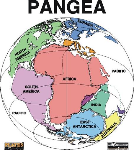
3. Continental Drift
A precursor to the theory of plate tectonics was the theory of continental drift put forward in 1912 by Alfred Wegener. The theory states that the continents were once joined together into a supercontinent called Pangea which began to split up about 200 to 300 million years ago. Wegener presented six key proofs that the continents were once joined together.
- coastline fit
- geologic fit
- paleoclimatology
- paleoglaciation
- fossil correlation
- paleomagnetism
Study the image below carefully. Can you see how the continents fit together like a jigsaw puzzle?
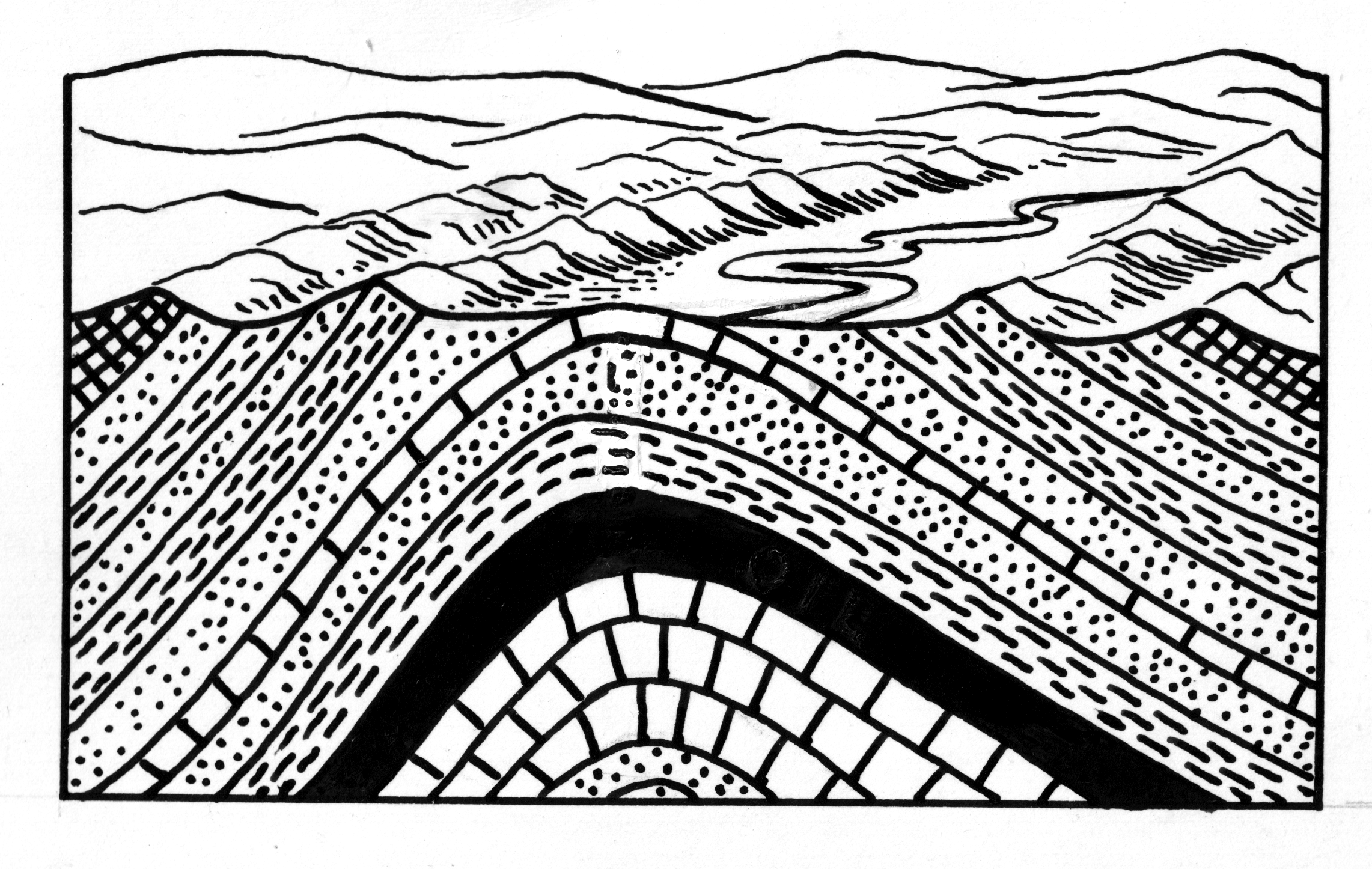
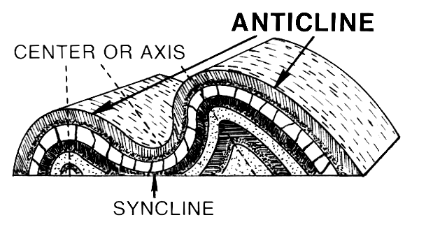
4. Folding
The earth's crust is constantly being changed due to tectonic forces. Compression, tension and sheer from plate movement can cause various kinds of deformation. Thick layers of rock can be bent, twisted and uplifted.
 |
 |
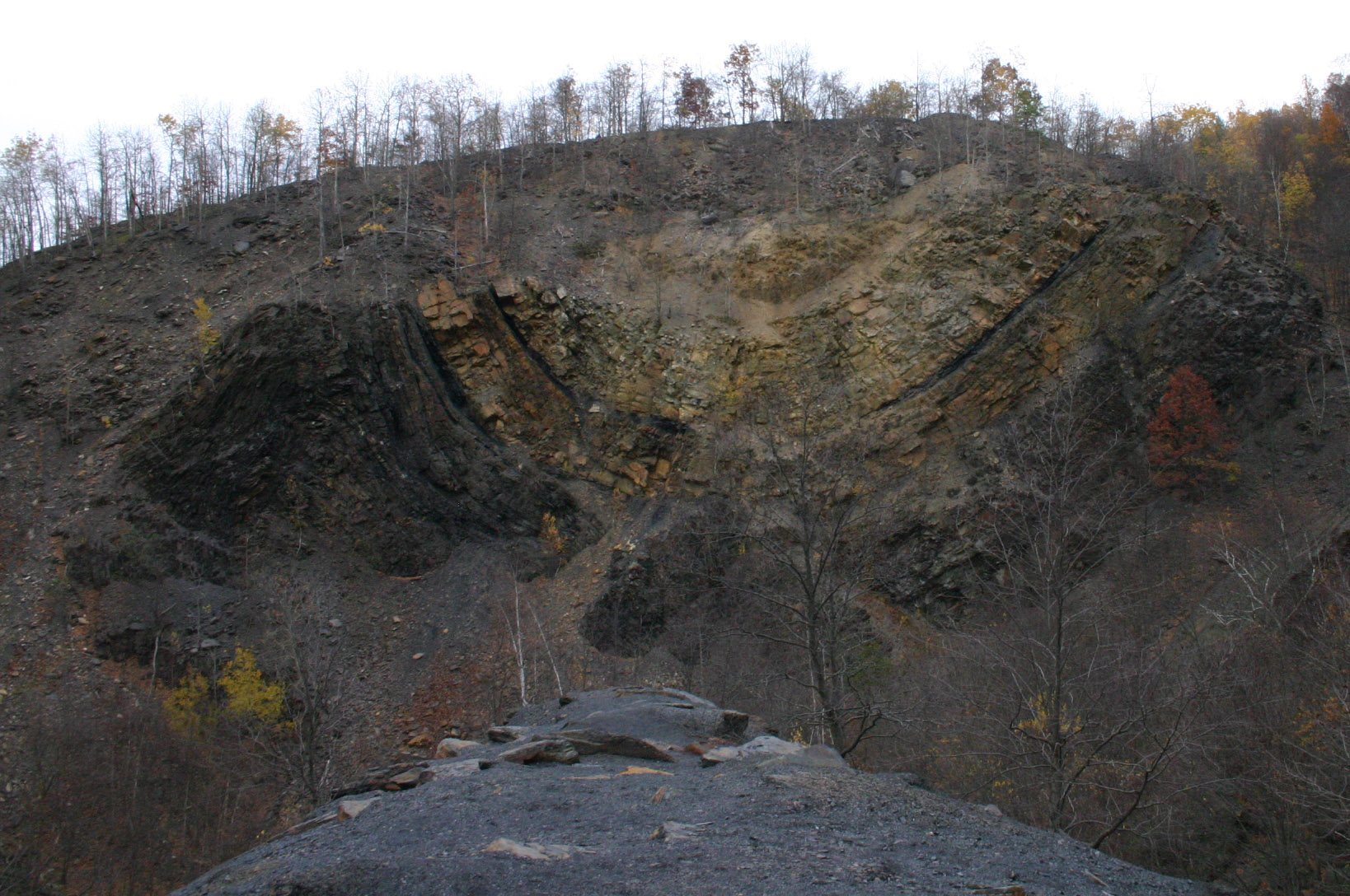
| Rock strata (layers) bent up into an anticline | An example of an anticline. |
If rock layers are bent down, this is called a syncline (think of "sinking" layers to help remember this.
 |
 |
| A diagram of a syncline (middle part of diagram) | An example of a syncline. |
As the picture above shows, anticlines and synclines often occur together. Try this: take a single piece of paper and push in from both ends; it should produce an anticline and a syncline. These structures are created deep inside the earth, but we as humans only notice them when they are exposed by weathering and erosion or human activities such as rock blasting.
5. Faulting
If rock is stressed enough, a fault may occur. A fault is simply a crack in the earth's crust. Faults can occur in the middle of a plate or at a plate boundary. The crust moves either vertically, horizontally or a combination of both (obliquely) on each side of the fault.
Fault types:
Normal Fault
In a normal fault, one section rises
up and over in comparison to the other, resulting in the hanging wall
overhanging the foot wall.
Reverse Fault
In a a reverse fault, one section drops down with no overhanging. Slip-strike fault
In a slip strike fault, the sections are sliding past each other.
 |
| Diagram of a slip-strike fault (from above) |
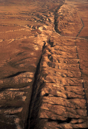 |
| The San Andreas fault in California is a famous example of a slip-strike fault |
Note it is not usually this simple. There can be a mixture of
horizontal and vertical movement in a fault. For example a horizontal
tear fault may occur with a reverse fault.
As well, there are often many faults occurring together, which geographers call a "fault zone."
Horsts and Grabens
- These fault types result in large blocks of crust either being raised up or sunk down. This often forms mountain ranges.
 |
| Diagram of Horst and Graben |
 |
| The Grand Teton Range of the Rock Mountains in Wyoming are an example of Horst or Fault Block Mountains |