EXPLORATION: Earthquakes and Volcanoes
| Site: | MoodleHUB.ca 🍁 |
| Course: | World Geography 30 |
| Book: | EXPLORATION: Earthquakes and Volcanoes |
| Printed by: | Guest user |
| Date: | Wednesday, 24 December 2025, 11:19 AM |
Description
1. Earthquakes
Within the earth, about a million tremors are produced each year. Of
these, about 1000 are major earthquakes. Most of these do not make
headlines because they occur in unpopulated areas or under oceans.
Charles F. Richter devised a scale in 1935 that measures the amount of
energy released by a shock or earth movement. The shock is graded on a
scale of 1 to 10.
Earthquakes are the result of a sudden
release of stress across a fault zone . The stress takes many years to
build up and then is suddenly released. Strain builds up until the
blocks along the fault are moved a few centimetres or many meters. A
slip at one weak point may trigger slips all along the fault. The sudden
movement causes seismic waves that travel out from the centre of the
slip. Example: 1906 San Francisco earthquake caused by a build up of
pressure along the San Andreas Fault. The pressure had been building up
on the Pacific side for 100 years.
- Shallow Earthquakes : cause the greatest destruction since their source of energy is very close to the earth's surface. Most quakes are of this variety. Shock lasts a fraction of a second to 10 seconds. Depth of shallow quakes varies from about 1.6 to 96 km.
- Deep Focus Earthquakes : Most of these occur near the deep oceanic trenches and are usually 6 to 7 in magnitude. Depth between 96 km and 960 km.
Epicentre: spot on earth's surface directly above the focus.
They can cause vertical and lateral displacement of parts of the crust. In Sagami Bay (Japan) in 1923, parts of the bay were uplifted by 215 metres. This can then trigger a tsunami In Alaska in 1899 some coastal rocks were uplifted by 16 metres.
- Near coastlines, harbors and rivers, they can make the wet, sandy soil jiggle, turning it temporarily from a solid to a liquid state. Heavy sand and rock sinks, while water and lighter sand bubble to the surface. The slurry spreads, often toward the water, and the surface shifts. This is known as liquefaction.
They can cause landslides.
They can cause the devastation of cities . (i.e. collapse of buildings, fires, death, disruption of utilities, spread of disease).
Earthquakes 101 - National Geographic
Watch
this video, noting your response in your learning guide as you do. Pay
attention to how the video shows you how earthquakes occur. Listen to
what it says about our ability to anticipate when and where an
earthquake will strike.
Causes of Earthquakes
There are two main belts: Pacific Rim and Portugal to South Asia
- In the Pacific, earthquakes are related to the giant convection currents moving the ocean floor.
- The belt of earthquakes passing through the continental mountain ranges of the Alps, Andes, Himalayas could be the result of mountains growing and decaying - this is called orogenesis . Erosion wears down the mountains making them lighter. To reach a state of equilibrium other areas rise causing earthquakes.
- The movement of continents and ocean floors exerts pressure at the trenches, ridges, and throughout the faults in the earth's crust.
- The earth wobbling on its axis may cause earthquakes. The earth wobbles a few centimetres each day totaling approximately 20 to 23 metres each year. These wobbles tend to maximize about every seven years.
- Human interference in the balance of nature.
- eg water injection: pumping fluids at high pressures into oil- bearing rock formations underground - forcing more oil into production wells. Quakes as large as 4.3 on the Richter scale have been produced at the Eagle oilfield north of Fort St. John, BC, underground nuclear bomb testing
Magnitude
Magnitude is the total amount of energy released by an earthquake, and consequently, the amount of ground motion it causes. Magnitude is measured using the Richter Scale. The scale grows by a power of 10 for each 1.0 increase in magnitude. Hence, a 5.0 earthquake is 1000 times (10 x 10 x 10) greater than a 2.0 earthquake.
Intensity
The intensity of an earthquake is a value that reflects the effect produced. Intensity is measured using the Modified Mercalli scale.
2. Volcanoes
Causes
Almost all volcanoes happen near plate divisions.
- Destructive (violent) volcanoes usually happen near subducting plates. i.e. The Pacific Ring of Fire
- Less violent volcanoes usually happen near diverging plates.
Watch the short video from National Geographic below. You will need to respond to this video in your learning guide.
- Cinder Cone
- basaltic magma ejected under high pressure from a narrow neck cools to form cinder and ash which falls back down to build the sides of the cone
- cone can build rapidly with steep sides i.e. 30 - 40 degree angle eg the volcano Paricutin in Mexico in 1943 grew 500 m in 8 months
- if the narrow neck of the cone becomes plugged the volcano can explode violently
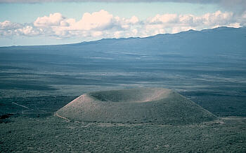
Photograph by J.P. Lockwood on December 1, 1975 (Courtesy: USGS) - Shield Cone e.g. Kilauea in Hawaii
- often formed from basalt lava which has a low viscosity allowing the lava to move for some distance forming a broad gently sloped volcano i.e. 10 -20 degree angle
- less explosive tendency because the magma flows freely allowing the gases to escape
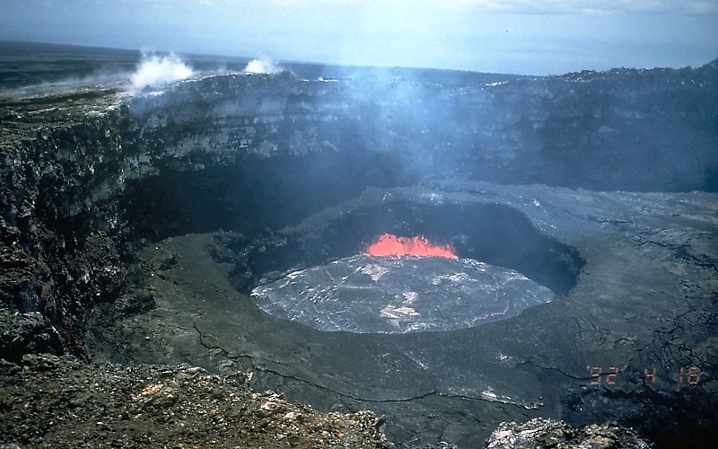
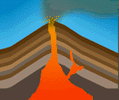
Photograph by M. Mangan on April 16, 1992 (Courtesy: USGS) - Composite Cone (or sometimes called Stratovolcanoes) e.g. Mt. St. Helens, Mt. Baker, Mt. Rainier, and Mt. Etna in Sicily
- consists of alternating layers of lava and ash
- shallow slopes at bottom, steep at top, looks like a "normal" mountain in many ways.
- lava layers permit the cone to attain considerable width while the cinder/ash layers encourage vertical growth
- as a result, some of the world's highest volcanic mountains are in this category
- can be very explosive spewing much material (i.e. cinders, ash, and
rock fragments) high into the atmosphere and / or rapidly down the side
of the volcano. Such a flow sears everything their path.
- mud flows, known as lahars, are frequently triggered as heat from the volcano melts snow and ice
Note: volcanoes often occur as "complexes" with different types of volcanoes together. Cinder cones often occur on the sides of shield or composite volcanoes.
Types of Volcanoes
3. Structures due to Volcanism
 Volcanism: the process involving the transfer of magma from one area to another.
Extrusive Forms
- if large volumes of lava cover existing landforms, a plateau may result. eg Columbia Lava Plateau in northwestern USA covers over 500 000 sq. km
with lava up to 0.8 km in depth - when a small opening is made in the crust and lava and other material gradually build up a cone-shaped structure surrounding the opening, this formation is known as a volcano
- the funnel-shaped opening at the top of the cone is known as the crater
- if a composite cone volcano erupts so violently that much of the
magma from the cone is ejected, it is left with little support,
resulting in an inward collapse of the cone leaving behind a depression
known as a caldera
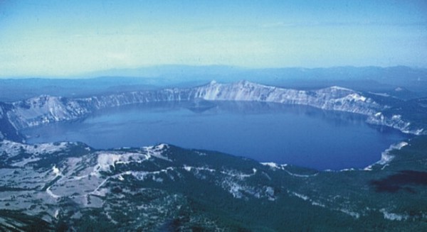
Courtesy: USGS
Intrusive Forms
Due to magma that solidifies in cracks and cavities that it has made as it forces the surrounding rock apart.
- wall or dike:magma that cools in a vertical crack
- sill: magma that flows between strata of sedimentary rock forming a thin but extensive sheet
- laccolith: dome of igneous rock formed from a large enough volume of magma to raise up the overlying strata
- batholith: a huge storage basin of magma several kilometres thick.

Courtesy: University of Wisconsin - La Crosse -
Note: It is possible for these features to become exposed at the surface over time due to weathering and erosion of the surrounding rock such as with the old volcanic neck below.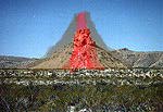 volcanic neck or plug: volcanoes,
of course, are extrusive igneous features -- but part of a volcano
cools underground and is considered an intrusive igneous feature. This
feature is known as the volcanic neck or plug.
volcanic neck or plug: volcanoes,
of course, are extrusive igneous features -- but part of a volcano
cools underground and is considered an intrusive igneous feature. This
feature is known as the volcanic neck or plug.
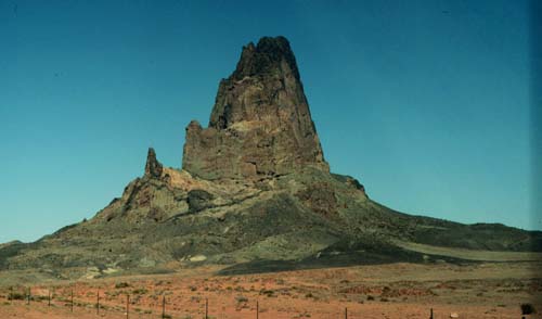
Courtesy: Texas A & M University
Destructive influences of Volcanoes
- some eruptions can cause great loss of life eg Krakatoa in 1883 (caused great sea waves which drowned 40 000 people in neighbouring islands; Mt. Pelee in 1902 (outpourings of gases killed 30 000 people).
- some eruptions can cause great damage to property eg Vesuvius buried the city of Pompeii with ash
Constructive influences of Volcanoes
- some lava outpourings have weathered to give fertile soils eg in Java, the northwestern-part of the Deccan Plateau, and the plains around Etna. These regions are of important agricultural value.
- volcanic activity sometimes results in the formation of precious stones and minerals. These occur in some igneous and metamorphic rocks. eg copper deposits of Butte, USA, nickel deposits of Sudbury, Canada.
Hot Springs
Superheated water which flows quietly to the surface after being heated by volcanic rocks forms hot springs.
Geothermal steam and hot water are used locally in New Zealand and Iceland to heat homes, dry crops, grow tropical prawns and heat swimming pools. Note: the white material in the video is steam.
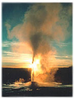 Geysers
Superheated water which is thrown out with great force and accompanied by steam is a geyser.
4. Stages of Volcanoes
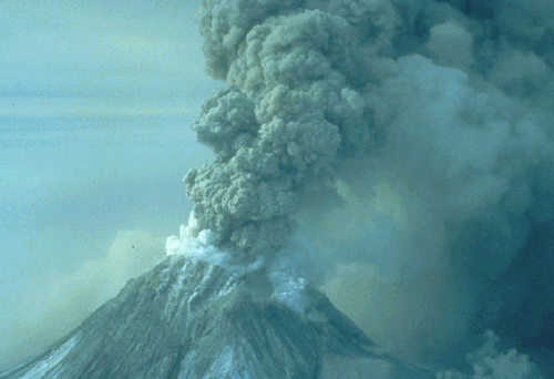
Below, we can see Mount St Helen's erupting in May of 1980. This volcano is just south of British Columbia, in Washington State. Ash from the volcano fell across BC including the Lower Mainland.
Below is a photo of Mount Edziza, a dormant volcano in the Stikine Valley of BC. 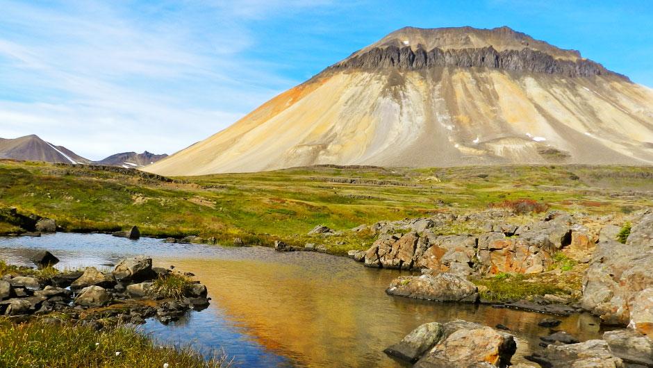
Photo of Mount Edziza from the Knowledge Network
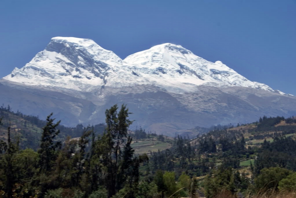
Huascarán,
located in the western Andes region of Peru, is a dormant volcano which
is the highest point in Peru and in all of the world's tropics.