EXPLORATION: Weather and Climate
| Site: | MoodleHUB.ca 🍁 |
| Course: | World Geography 30 |
| Book: | EXPLORATION: Weather and Climate |
| Printed by: | Guest user |
| Date: | Wednesday, 24 December 2025, 11:20 AM |
1. Introduction
Meteorology is the study of weather. Weather is caused by the movement or transfer of energy. Energy is transferred wherever there is a temperature difference between two objects. Many weather phenomena result from a transfer of energy that occurs via the movement of air in the atmosphere. This is known as convection.
Air contains water vapour from the evaporation of liquid water sources on the Earth's surface, including oceans, lakes and rivers, and from evapotranspiration by plants. When air is moved about the Earth, either vertically when uplifted or horizontally as part of air masses, it may cool and release water vapour as condensation in the form of clouds and eventually rain and other forms of precipitation, which is returned to Earth. This cycle of evaporation, condensation and precipitation between the Earth and the atmosphere is known as the water cycle.
The physical transfer of heat and moisture by convective processes is the basis for the formation of many meteorological patterns and features, including anticyclones, depressions, fronts, monsoons, thunderstorms, hurricanes and tornadoes. Heat however, may also radiate directly from a hot object to a colder one, without involving the movement of air. Many small-scale weather phenomena are the result of this form of heat transfer, including dew, frost and fog.
Weather can be simply measured by observing and recording temperature, rainfall, pressure, humidity, sunshine, wind and cloudiness. It is also possible to identify and name different types of clouds, which are associated with different patterns of weather. Commonly observed cloud types include cirrus, cumulus, cumulonimbus and stratus.
Weather averages measured over longer periods of time, about 30 years or more, is referred to as climate. Often, these terms are confused, as they measure the same phenomena. However, we have to be very careful in making it clear if we are referring to weather which is fast-changing - such as if it will rain over the next few days - or climate, which is a predictable pattern of conditions over decades or centuries.
Text on this page from Enviropedia UK
2. Air Pressure
Standing on the ground and looking up, you are looking through the atmosphere. It might not look like anything is there, especially if there are no clouds in the sky. But what you don’t see is air – lots of it. We live at the bottom of the atmosphere and the weight of all the air above us is called air pressure.
Pressure varies from day to day at the Earth’s surface - the bottom of the atmosphere. This is, in part, because the Earth is not equally heated by the Sun. Areas where air is warmed often have lower pressure because the warm air rises and are called low pressure systems. Places where air pressure is high are called high pressure systems.
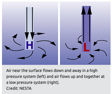 A low pressure system has
lower pressure at its center than the areas around it. Winds blow
towards the low pressure, and the air rises in the atmosphere where they
meet. As the air rises, the water vapor within it condenses forming
clouds and often precipitation too. Because of Earth’s spin and the
Coriolis Effect, winds of a low pressure system swirl counterclockwise
north of the equator and clockwise south of the equator. This is called
cyclonic flow. On weather maps a low pressure system is labeled with red
L.
A low pressure system has
lower pressure at its center than the areas around it. Winds blow
towards the low pressure, and the air rises in the atmosphere where they
meet. As the air rises, the water vapor within it condenses forming
clouds and often precipitation too. Because of Earth’s spin and the
Coriolis Effect, winds of a low pressure system swirl counterclockwise
north of the equator and clockwise south of the equator. This is called
cyclonic flow. On weather maps a low pressure system is labeled with red
L.
A high pressure system has higher pressure at its center than the areas around it. Wind blows away from high pressure. Winds of a high pressure system swirl in the opposite direction as a low pressure system - clockwise north of the equator and counterclockwise south of the equator. This is called anticyclonic flow. Air from higher in the atmosphere sinks down to fill the space left as air blew outward. On a weather map the location of a high pressure system is labeled with a blue H.
How do we know what the pressure is? How do we know how it changes over time? Today, electronic sensors are used to measure air pressure in weather stations. The sensors are able to make continuous measurements of pressure over time. In the past, barometers were used that measured how much air pushed on a fluid such as mercury. Historically, measurements of air pressure were described as “inches of mercury.” Today, meteorologists use millibars (mb) to describe air pressure.
Text and graphic from UCAR Centre for Science Education
3. Temperature and Climate
Why does temperature vary so much in the world?
Ocean Currents: can either warm or cool a coastal area by approximately two degrees Celsius. The image below shows the major cool and warm currents of the world.
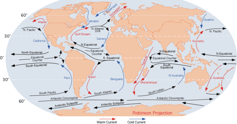
Note: Winds produce currents.
- e.g. Los Angeles: California Current (cool)
- Scotland: Norwegian Current (warm), gives warm winters
- Halifax: Gulf Stream Current (warm)
Latitude: the further north you go in the northern hemisphere, the colder it gets.
Why?
-
- Curvature of the earth: the sun strikes the earth in a very concentrated fashion at the equator, whereas at the poles, the sun's rays are much more spread out.
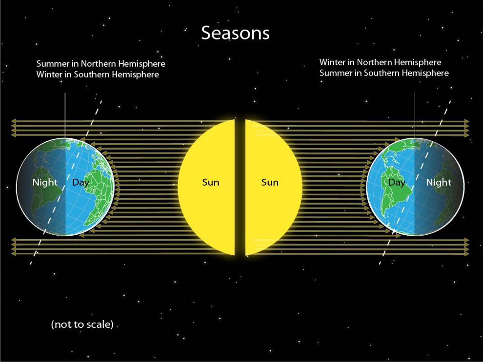
- The seasons: spring, summer, fall, and winter result in different
amounts of heat coming to the earth. This is caused by the changing
position of where the sun is directly overhead on the earth's surface
during the year and the tilt of the earth's axis. In the northern
hemisphere's winter, we are titled away from the sun and receive less
daylight. During summer, we are titled towards the sun and receive more
daylight.
Note that the polar regions of Canada can have 24 hours of darkness in winter and 24 hours of daylight in summer.
i.e. Mar. 21 (Vernal Equinox) and Sept. 21 (Autumnal Equinox): the sun is directly overhead at the equator.
Dec. 21 (Winter Solstice): the sun is directly overhead at the Tropic of Capricorn (23.5 S).
June 21 (Summer Solstice): the sun is directly overhead at the Tropic of Cancer (23.5 N).
Look at the diagram below, from National Geographic, which shows how the angle of the sun's rays on the spherical surface of Earth produces our seasons.
Altitude: the higher you go up, the colder it gets.
Why? Less dust, greenhouse gases, water vapour, etc. to trap heat coming up from the earth's surface.
Environmental lapse rate: 1 deg. C drop for every 150 m rise or 6.4 deg. C drop for every 1000 m
Mountain Barriers: impede the movement of cold air masses. This is due to the fact that cold air is dense and generally stays near to the ground.
e.g. Vancouver is shielded from most Arctic air masses by the Rockies and Coast Mountains.
Mountains can also result in warm winds descending down slope.
Prevailing Winds: southerly: brings warmer air - northerly: brings colder air
Nearness to Water or Continentality: the closer a city is to a large body of water, the more moderate will be its temperatures (i.e. maritime climate), whereas the further away a city is from the water, the greater the temperature extremes (i.e. continental climate).
Amount of Cloudiness:
Cloudy conditions generally
produce cooler days (i.e. less solar radiation is able to reach the
earth) and warmer nights (i.e. clouds act as a blanket to keep in heat
emitted by the earth)
- the amount of cloudiness is dependent upon the air pressure
Low Air Pressure: cloudy conditions
High Air Pressure: clearer conditions
Slope of the Land (also known as Aspect)
- largely a micro-climatic control
- in the northern hemisphere, a north facing slope results in cooler temperatures whereas a south facing slope has warmer temperatures
4. El Niño
Overview of El Niño
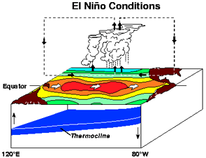
El Niño is generally thought of as a phenomena that originates every few years off the west coast of South America. In order to understand it, it is useful to review what normally happens in that area in terms of winds and ocean temperatures.
Normal Situation
Off the coast of Peru, the prevailing winds are the SE Trades which help to blow warm water away from the west coast of South America. This allows colder water from below to come to the surface. This colder water contains nutrients which anchovies eat. Therefore, the anchovy industry has been important to the Peruvian economy. In 1982, a severe "El Niño" event devastated the Peruvian anchovy industry.
Why do they happen?
El Niño appears every few years often around Christmas time as evidenced by the unusual warming of the surface waters near the west coast of South America. As a result of it frequently starting around Christmas, the event has been given the name "El Niño" which means "The Little Boy" or "Christ Child" in Spanish. The warming is due to a weakening of the prevailing winds so that warm water is not blown away from the coast. Rather the water gets warmer and encompasses a larger area. Consequently, the colder water and nutrients from below do not reach the surface.Watch the short video below to gain an understanding of the physics behind El Niño events, how these weather events affect sea life and fisheries and how the effects are felt on land.
La Niña
Every few years, the opposite of El Niño occurs - "La Niña" ("The Little Girl" in Spanish). In this situation, rather than weakening, the trade winds strengthen, blowing more warm water away from the west coast of South America. This allows an unusual amount of cold water to come to the surface. The effects of La Niña are the opposite to those of El Niño so areas that become drier under El Niño become wetter under La Niña. Generally though, the impacts of La Niña are less severe than those under El Niño.