EXPLORATION: Weather and Climate
4. El Niño
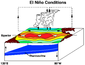
Overview of El Niño
El Niño is generally thought of as a phenomena that originates every few years off the west coast of South America. In order to understand it, it is useful to review what normally happens in that area in terms of winds and ocean temperatures.
Normal Situation
Off the coast of Peru, the prevailing winds are the SE Trades which help to blow warm water away from the west coast of South America. This allows colder water from below to come to the surface. This colder water contains nutrients which anchovies eat. Therefore, the anchovy industry has been important to the Peruvian economy. In 1982, a severe "El Niño" event devastated the Peruvian anchovy industry.
Why do they happen?
El Niño appears every few years often around Christmas time as evidenced by the unusual warming of the surface waters near the west coast of South America. As a result of it frequently starting around Christmas, the event has been given the name "El Niño" which means "The Little Boy" or "Christ Child" in Spanish. The warming is due to a weakening of the prevailing winds so that warm water is not blown away from the coast. Rather the water gets warmer and encompasses a larger area. Consequently, the colder water and nutrients from below do not reach the surface.Watch the short video below to gain an understanding of the physics behind El Niño events, how these weather events affect sea life and fisheries and how the effects are felt on land.
La Niña
Every few years, the opposite of El Niño occurs - "La Niña" ("The Little Girl" in Spanish). In this situation, rather than weakening, the trade winds strengthen, blowing more warm water away from the west coast of South America. This allows an unusual amount of cold water to come to the surface. The effects of La Niña are the opposite to those of El Niño so areas that become drier under El Niño become wetter under La Niña. Generally though, the impacts of La Niña are less severe than those under El Niño.